Sunday, July 21, 2013

Wandering around pictures

Here are a few snaps I wanted to share, in no particular order...
The cast of the Follies playing classical music with a violin bow on saw blades....
Teslin First Nation artist displaying moose hide mittens and bead work. Very nice!
Yours truly cooking pancakes at Teslin breakfast.
Nancy caught me looking at this little waterfall. The stone island in the middle splits the river in two, each side flowing down and around it to rejoin.
Half the bridge under reconstruction, so that left us about 9', pretty tight for 81/2 foot wide rigs!
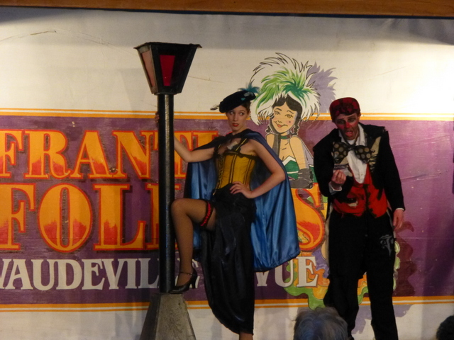
One of our Fantasy caravan members gets drafted to assist the magician in a trick on stage at the Follies
Propositioning the streetwalker at the Follies... I'm told that the Follies get more and more risque as we travel further north and west!

Welcome to Whitehorse

Blue seems an appropriate color for this post, as the sky is a brilliant blue, and the mountains a dusky blue, and the rivers a dark blue green. Lots to see. This is the first big town we've seen since Dawson City.
We started our stay with a catered dinner at the nice wood paneled meeting room at our RV park. One of our guests brought some wine to share. Whoopee!
The next morning we took a bus tour of Whitehorse, population about 28 thousand, and the capitol of the Yukon territory. Stopped at a viewpoint over the canyon, enjoying the mountains and clouds.
We spent some time at the Klondike Steam Ship, which was the main mode of transportation to Whitehorse from Dawson City back in the day.
This sternwheeler was designed to carry cargo and passengers on the river, and could carry 300 tons with a draft of only 6 feet! Check out the paddlewheel:
It was turned by a 500+ horsepower two piston steam engine. Check out the size of the pistons:
A friend caught a snap of Nancy and I in the cargo hold. The ship is very well preserved, and a Provincial Historical Site.
The ship has a nice sitting room to play cards or visit while you are steaming on the river. Dawson City to Whitehorse, 3 days; Whitehorse down, 36 hours. Burns 2 cords of wood per hour going upstream.
On the way back to the campground the bus passed the airport. They had this 40's vintage refueling rig for airplanes on display. Cool.
We took in the Frantic Follies in the evening, a slapstick vaudeville type show. Got out at 10:30, still daylight.

Teslin and the First Nation People

Canada is very respectful of their native peoples, often called the First Nation. As we travel further north, it is obvious that these folks deserved respect for being able to survive and prosper in the harsh winter weather here. There was an interpretive center in Teslin, where we visited with a matriarch whose family lives in the traditional ways.
She told of cutting their 10 cords of wood in the fall, of hunting for moose, tanning the hides, and displayed her beadwork and moosehide gloves.
Our campground in Teslin was on the Teslin Lake, which drains in to the Teslin River, running 400 km to join the Yukon River and ultimately drain into the Bering sea in Alaska. We are parked to the right of the bridge, by the tall trees on the far bank.
Here's a picture from the campground looking back at the lake.
Totem poles outside the Teslin interpretive center.
We were hoping for some salmon, but this guy didn't want to share. I caught him at lunch along the river.
Just kidding! This stuffed grizzly was on display inside the nature exhibit in Teslin, very well done, eh?

On the Road again...Just can't wait to get on the Road again...

The scenery is a never ending tapestry of meadows, wildflowers, rivers, and mountains. I'll share a few snapshots with you here. Sure seems like there should be moose or caribou down there, but we didn't see them!
Brooding mountains were the backdrop to almost every scene, portending challenges to come in the RV.
Nancy met an interesting bearded lady on our stop to see a waterfall, and she told us of the fire weed flowers, and what they tell of the coming winter.
She said that the fireweed is the first plant to sprout after a forest fire. And, that as the blooms open from the bottom to the top of the stalk, it predicts the coming of winter. When the top blooms open, snow is six weeks away. You can see, we're not far from the top.
We saw this interesting pattern on some leaves, perhaps caused by some insect feeding?
Nancy scopes out the falls and river in this little canyon. As you might imagine, the water is COLD.

Saturday, July 20, 2013

Watson Lake and the Sign Forest!

What, you may ask, is a sign forest? How did it get started? Click here to find out! There are thousands of signs now, from all over the world. Of course, we had to add our own!
 Our wagonmaster, John Orbeck, had all of us sign a board he'd brought with our names and home town and state. He'd then coated it with urethane to weatherproof, and we went off to the forest to find a spot. As you can see, he picked a high one! And I am the guy on the top of the ladder! Fortunately, I had a volunteer to push on my butt so I didn't fall over backwards putting it up!
Meanwhile, Nancy was wandering around the hundreds of poles, glancing at signs, and found two that are worth mentioning here... the first happens to be put up by her brother Carl only a few weeks ago, unbeknownst to us! Here she is pointing it out.
Nancy also spotted the one below from the home town of her principal at Withrow School in her teaching days.
Before returning to our rigs, we all gathered under the Fantasy RV Tours signboard we'd autographed for a group picture. Fun!

Liard Hot Springs

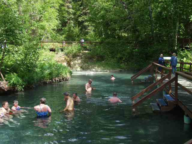
One of the gems on this trip is the hot springs at Liard (pronounced lay-ARD). As luck would have it, we camped there on a hot day... too bad it wasn't 50 degrees, it would have been even more of a treat! 
There is a nice new changing room above the boardwalk, but we walked down in our suits with a towel. Water is really toasty, and more so as you walk upstream toward the spring. If you are macho, you put a rock on the ledge by the spring. 

If you want to cheat a little, you can stir some of the cooler water at your feet into the hot upper layer, and make it a bit easier. Temp can reach into the 120's so be careful!
Our campground was in the Provincial Park, and had nice large and private sites, very quiet. No hookups but very enjoyable for an overnight.
The plant life around the springs is tropical, with ferns and other plants found nowhere else in the Yukon.
In the winter, the steam rapidly condenses on the plants and forms a fairyland of ice, like this:
Obviously, I had to "steal" this picture, as we are here in July!!!

Thursday, July 18, 2013

Fort Nelson, BC


Northern Alberta from Dawson Creek to Fort Nelson is mostly plains, either planted with crops of wheat and canola, or grasslands. As we traveled further north, the land became less tilled, and more prairie, and in the distance to the west we could see the silhouettes of the foothills of the Canadian Rockies.
The further north you go, the more spectacular the views become. Often, the road follows the rivers.
Along the shores we watched for caribou, moose, deer, and bears.
Not much to see up here in Canada...   NOT

Saturday, July 13, 2013

North, to Alaska, goin' home to Russia's own

Today was "D"day. That is, Dawson Creek day, where we rendezvoused with our Wagonmasters John and Arlene Orbeck, our leaders on the 48day Alaska FMCA tour with Fantasy RV Tours. RAH! 21 rigs plus us and the Wagonmasters gather here to get acquainted, briefed, inspected, stickered, fueled up, and ready to go on Monday. We drove up from Calgary in two days, thru 24 hours of heavy rain. Fields are green and crops look great due to lots of water.
The bright yellow fields are canola, which is a big crop here in Alberta, used to make canola oil.
Roads so far are excellent, mainly 4 lane divided highway with stretches of 2 lane, and light traffic. Have yet to see a highway patrolman in Canada.
Saw these pretty Magpies everywhere, along the roadside and in the grass.
We drove up the ALCAN highway about 17 miles north of Dawson Creek to get a look at the only remaining wooden trestle bridge from the original highway construction in 1942. We were lucky enough to meet two Ford Model A's coming south... They were from Texas, and had driven their A's all the way to Fairbanks and were on their way home! No chase car, just two oldies. Took a picture of the nice yellow '29 on the bridge, the sedan is in the background.
Were it not for the bombing of Pearl Harbor and the occupation by Japan of two of the Aleutian Islands, the Alaskan Highway would probably not have been built. Certainly not in the '40's. 1533 miles from Dawson Creek to Fairbanks, it was completed through largely unmapped wilderness by the Army Corps of Engineers (with civilian US and Canadian contractors helping) in only 8 months. Quite a feat.
We checked out the visitors center at Mile Zero, and watched a film documenting the construction. One interesting tidbit: Three military units of black troops (with white officers, of course!) participated in the construction. The brass expected them to fare poorly. Instead, they performed so well that all 3 units received unit citation medals for their efforts, proving that they could compete with any other unit, and boosting the status of blacks throughout the US Army.